

| | COUNTRIES | Geographic.org | GEOLOGY | USA STATISTICS | CHINA STATS | COUNTRY CODES | AIRPORTS | RELIGION | JOBS | |
 | |
 |
|
 | |
New Zealand Photoshttps://allcountries.org/photos/new_zealand/new_zealand_photos_39.html | |
 | |
|
OTHER ITA WEB SITES: - Human Anatomy - Health Topics - Drug Reference Encyclopedia - Genome Dictionary - HIV/AIDS Glossary - International Classification of diseases - Geology Dictionary - All About Diamonds - Energy Dictionary - USA Census Statistics - China Statistics - HTML Color Chart - Seaport Codes - Airport Codes |

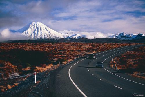
Desert road Between the trout town of Turangi and the army town of Waiouru, State Highway 1 sweeps through a windswept tussock plain known as the Rangipo Desert. This arid, semi-alpine area borders the eastern side of Tongariro National Park, where the volcanoes of Tongariro, Ngauruhoe and Ruapehu reign supreme. SOURCE: David Wall, courtesy of New Zealand Tourism, used with permission To submit a photo for inclusion in this web site, please send e-mail for instructions. NOTE: The information regarding New Zealand on this page is re-published from New Zealand Tourism. No claims are made regarding the accuracy of New Zealand information contained here. All suggestions for corrections of any errors about New Zealand should be addressed to New Zealand Tourism.  - Please bookmark this page (add it to your favorites).
- If you wish to link to this page, you can do so by referring to the URL address below this line.
https://allcountries.org/photos/new_zealand/new_zealand_photos_39.html
This page was last modified 25-JAN-09 Copyright © 1995-2023 ITA all rights reserved. |
|